Acquisitions: Maps

Showing 1 - 3 of 3 results
An old black and white map of the Sunda Strait decorated with pictures of navigational symbols, landmarks and ships

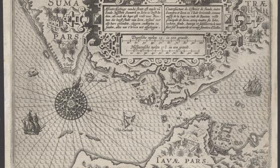
Lucas Janszoon Waghenaer, Afconterfeytinge van die strate oft engde van Sunda, tusschen Sumatra en Iava in Oost Indien, als oock die baye oft rede voor Bantam die hooft-stadt van Iava, tesamen met alle hare eylanden, clippen, ondiepten en sanden, alles nae t' leven net afgetogen, c.1602, nla.gov.au/nla.obj-3444422116

Rare 1602 map of the Sunda Strait

A very rare chart of the Sunda Strait – located between the Indonesian islands of Sumatra and Java – from 1602 has recently been added to our collection.

News article
A black and white map showing Australia, then called New Holland, in the late 1600s.
Two recently acquired Coronelli globe gores

The Library has recently acquired two 17th century globe gores by Vincenzo Coronelli.

News article
Antique map showing a partial outline of Australia
Blaeu map added to the UNESCO Australian Memory of the World Register

The map includes details of the first sighting of Tasmania by Europeans and the first mapping of New Zealand.

News article

Need help?

Our librarians are here to guide you.

Ask a librarian