The Vereenigde Oostindische Compagnie
About the Vereenigde Oostindische Compagnie
By the mid-1700s, the VOC had built about 1,500 ships and employed more than 25,000 people. Between the 1600s and 1700s, VOC ships made nearly 5,000 voyages, many of which passed the coast of Australia—then known to Europeans as New Holland. Some of these ships were wrecked along the dangerous Western Australian coast, leaving survivors stranded in unfamiliar territory.
The VOC had the wealth and military power to control the international spice trade. It secured a monopoly on nutmeg and mace in the Banda Islands in 1622, and took control of the clove trade in Makassar in 1667. The company also dominated trade in cinnamon and pepper.
The VOC played a key role in exploring the Australian coastline. In 1606, Willem Janszoon, sailing the Duyfken, landed near Cape York. This marked the beginning of Dutch–Australian connections—more than 170 years before James Cook’s voyage.
A 1717 map by Herman Moll shows European territorial claims in the East Indies, including spice trade routes and settlements.
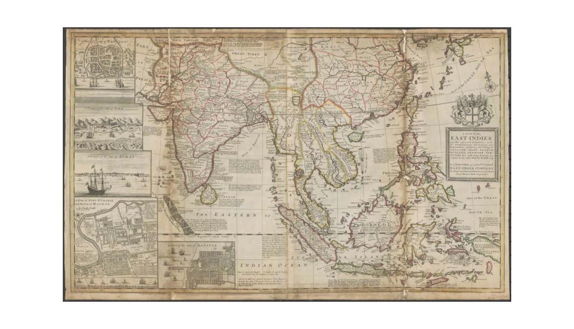
Herman Moll & William Dampier, Collection of voyages, A map of the East-Indies and adjacent countries [cartographic material] : with settlements, factories, and territories : explaining what belongs to England, Spain, France, Holland, Denmark, Portugal, etc. with many remarks not extant in any other map, 1729, nla.gov.au/nla.obj-231221936
Herman Moll & William Dampier, Collection of voyages, A map of the East-Indies and adjacent countries [cartographic material] : with settlements, factories, and territories : explaining what belongs to England, Spain, France, Holland, Denmark, Portugal, etc. with many remarks not extant in any other map, 1729, nla.gov.au/nla.obj-231221936
Learning activities
Australia on the world map
Show students this video, prepared by the National Library of Australia, as part of the Mapping Our World exhibition in 2014.
Digital Classroom: Dirk Hartog 1616-2016 - 400 years of Dutch-Australian connections
Use a smartboard to display online links to the 12 maps below, in chronological order. A PDF with background information on each map is available:
- Copy of 1606 Map of path of the Duyfken
- 1627 Map of the Land of Eendracht, by Hessell Gerritsz
- 1639 map of SouthEast Asia by Hendrik Hondius
- 1647 Map of the Moloccan Islands by Willem Blaeu
- 1658 Map of India, by Jan Jansson, taken from Hendrick Doncker Altas
- 1663 Map, Archipelagus Orientalis, sive Asiaticus by Apud Ioannem Blaeu
- 1673 Map from the Typus orbis terrarium, or Ortelius Atlas
- 1744 Complete Map of the Southern Continent by Emanuel Bowen
- 1745 Map of Sunda Strait by Isaac de Graaff
- 1751 Map by Sutton Nichols
- Map depicting “The part borne by the Dutch in the discovery of Australia 1606-1765”
- 1814 Map of Australia by Matthew Flinders
Activity 1: How was Australia mapped?
Students will explore how maps evolved over time. In groups, provide 2–3 printed maps for discussion.
Discussion questions:
- What makes one map look older than another?
- What features are similar or different?
- Which map shows more detail about Australia?
- Which map was created first?
- Why would people create maps or explore other lands?
Have each group present to the class. Use the smartboard to compare the maps and discuss how depictions of Australia changed over time.
Class prompts:
- What influenced whether an area was mapped?
- Why does only the west coast appear on early maps?
- What decorative features are included—and why?
- Why did it take so long for Australia to appear fully on world maps?
- How long would a voyage from Amsterdam to Asia take?
People of the Vereenigde Oostindische Compagnie
Between 1602 and 1796, the VOC sent nearly a million Europeans to work in Asia aboard almost 5,000 ships. Students will investigate VOC figures, including both famous and lesser-known individuals.
Activity 2: Investigating VOC figures
In pairs, students will research one of the following:
- Willem Janszoon
- Frederick de Houtman
- Francisco Pelsaert
- Abel Tasman
- Dirck/Dirk Hartogh
- Pieter Albertsz / Albertszoon
- Anthony van Diemen
- Willem Hesselsz de Vlamingh
- Jan Carstensz / Carstenszoon
- Pieter de Carpentier
- Pieter Nuyts
- Gerrit Frederikszoon de Witt
- Salomon Sweers
- Frederick Hendrick van Orange-Nassau
Biography criteria (half page):
- When and where did this person live?
- What was their role in the VOC?
- Are places in Australia named after them?
- Can you find an illustration?
Display the biographies in order of birth year to show the time span of the VOC.
Activity 3: Mapping Dutch influence on Australia's geography
Students label Australian places named after Dutch figures they researched. Examples include:
- Arnhem Land
- Cape Inscription
- Groote Eylandt
- Rottnest Island
- Maria Island
- Cape Leeuwin
There are over 200 Dutch-named places in Australia. Students can find and add more to their maps.
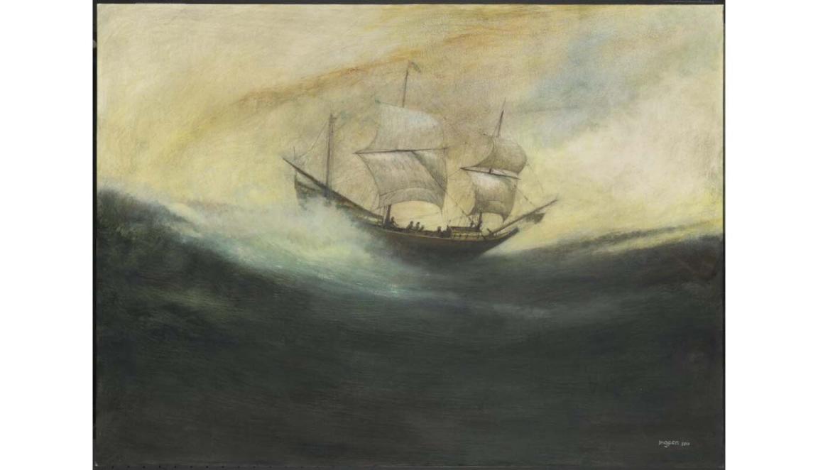
Robert Ingpen, The Duyfken off Australia, 1606, nla.gov.au/nla.obj-138210565
Robert Ingpen, The Duyfken off Australia, 1606, nla.gov.au/nla.obj-138210565
The Duyfken
The Duyfken was one of the first ships of the VOC. In 1605, Willem Janszoon sailed it in search of gold and trade routes. The National Library holds a 2011 painting by Robert Ingpen showing the ship battling rough seas.
Janszoon charted the southern coast of New Guinea, then sailed further south to Australia. In 1606, the Duyfken mapped about 320 km of coastline near Cape York, making landfall at the Pennefather River.
This was the first recorded European contact with Indigenous Australians, the Wik people. Janszoon thought he had reached an extension of New Guinea—but he had charted the Australian continent.
This was a key moment in global cartography: all inhabited continents were now known to European mapmakers.
Activity 4: 1606 and the arrival of the Duyfken
Have students revisit the Duyfken chart from Activity 1. The map wasn’t discovered until 1933 in Vienna and shows an accurate depiction of the Gulf of Carpentaria.
Have students compare the 1606 map with the Google map of Australia today, considering the following questions:
- What similarities and differences can you find?
- Why do you think Janszoon thought it was an extension of New Guinea?
- How far in kilometres is the distance between the tip of Australia and Papua New Guinea?
- Can you identify the parts of Papua New Guinea on the 1606 map?
- Look closely at the islands in the Torres Strait, on Google Maps. Do you think people living on these islands might have had contact with people in Papua New Guinea?
Activity 5: Exploring early encounters, voyages and legacies in northern Australia
Have students choose a research topic and investigate one or more of the following:
- The other voyages taken by the Duyfken, in its service to the VOC
- Other voyages to that area, by merchants of the VOC
- The building of a replica of the Duyfken and the ship’s planned activities in 2016
- The exchange that took place between the crew of the Duyfken and the Wik people they met in the Gulf of Carpentaria
- The cultures of the language groups in the Gulf of Carpentaria and Torres Strait
- The agreement with Papua New Guinea as to the governance of the islands in the Torres Strait
- The life of Edward Koiki Mabo
- Torres Strait Islander conservation
Other Digital Classroom resources that relate to the concepts explored in this source include:
Acknowledgement
This resource has been generously supported by the Embassy of the Kingdom of the Netherlands in Australia, to commemorate the 400th anniversary of the arrival of Dirk Hartog on the West Australian coast in 1616.
More to explore