The Angkor/Khmer Empire (802–1431)
About this module
Using an inquiry-based approach, this module develops students' skills as historians through engaging historical sources. Featuring sources from the National Library's collections, the resource caters for flexible approaches to suit diverse classroom contexts and learning styles.
Copyright for teachers
You can download all collection materials in this resource for education purposes. For more information, go to copyright for teachers.
Topics in this module
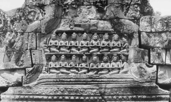
Yves Coffin, [Banteay Kdei, pediment], nla.gov.au/nla.obj-140372605

Yves Coffin, [Preah Khan, rows of stone posts lined towards gopura], nla.gov.au/nla.obj-140374253
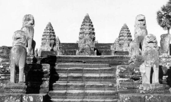
Yves Coffin, [Angkor Wat, perron of main temple and sculptures], nla.gov.au/nla.obj-140376052
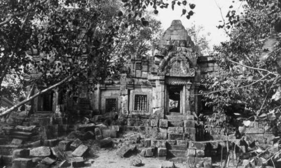
Yves Coffin, [Wat Ek, comprehensive view, southern side], nla.gov.au/nla.obj-140371255
Introductory activities
Activity 1: Exploring prior knowledge
What do you know about Cambodia? As a class, discuss what students already know or would like to know about Cambodia and the Khmer Empire. Record ideas to revisit later.
Activity 2: Mapping the Khmer Empire
Using an atlas or an internet map service, locate Cambodia and identify the following key cities:
- Angkor
- Hariharalaya
- Tonlé Sap
- Phnom Penh
Consider:
- How close are these cities to other modern states and territories?
- What geographic advantages or disadvantages might these locations have?
- Are there any common geographic features?
Activity 3: Global connections in time
The Khmer Empire existed from 802 to 1431. On a blank world map, mark events that occurred globally during this period. Use symbols or images to represent different types of events such as wars, political changes, major constructions, or cultural achievements. Group them by category to identify patterns or themes.
Activity 4: The language of kings
The Khmer Empire used Sanskrit, the sacred language of Hinduism and Buddhism. Many rulers had names with Sanskrit roots—for example, Jayavarman, Indravarman, and Isanavarman.
Research a list of Khmer kings.
- Identify repeated name elements and their meanings (for example, "-varman" meaning "protection" or "shelter").
- Why do you think many rulers shared these name elements?
- What might this reveal about the values or traditions of the empire?
Concluding activities
Activity 5: Virtual tour of Angkor
Using an internet map service like Google Maps and Street View, explore the Angkor site in Cambodia.
- Try “walking” into Angkor Wat and look closely at the sculptures on the walls and statues in the courtyards.
- Describe your impressions of the buildings. What do you think the artworks mean or represent?
- What features or details stand out to you, and why?
Activity 6: Reconstructing the past with technology
Watch digital reconstructions of life in Angkor on the Virtual Angkor website. This website is a collaboration between archaeologists, historians and virtual history specialists from Australia, Cambodia and the United States.
- Observe the scenes and consider what they reveal about how people lived, worked and worshipped.
- How does this bring history to life for modern audiences?
- Compare what you see with what you learned from the Google Maps exploration.
Note: All images and works featured on Virtual Angkor are copyright Monash University (SensiLab). Please do not reproduce without permission.
Activity 7: Exploring the Coffin Collection
The Coffin Collection includes photographs of Angkor and other Khmer sites taken mainly in the 1960s. Many focus on sculpture and architectural elements.
- View the Coffin Collection
- Access the digitised selection of these photographs through the catalogue
- Choose an image that interests you and describe what it shows
- How might these photographs help researchers and students learn more about the Khmer Empire?
Curriculum links
This resource aligns with the Australian Curriculum: History ‘Asia-Pacific world’ for Year 8 students.
- The significant social, religious, cultural, economic, environmental and/or political features of different groups in the Asian-Pacific society (AC9HH8K12)
- A significant development, event, turning point or challenge that contributed to continuity and change in the Asian-Pacific society (AC9HH8K13)
- The experiences and perspectives of rulers and of subject peoples, and the interaction between power and/or authority in the Asian-Pacific society (AC9HH8K14)
- The role and achievements of a significant individual and/or group in the Asian-Pacific society (AC9HH8K15)
- Interpretations about the Asian-Pacific society and events, and/or individuals and/or groups connected to the society (AC9HH8K16)
More to explore